Romania · Poland · Czechia · Slovakia · Italy · Germany
Six national grids. One app.
Numbers you can check.
Stereo 70, PUWG 1992, S-JTSK Křovák, Gauss-Boaga and ETRS89/UTM to WGS 84 and back. The maths runs on your phone with no signal and no account, and every country shows its accuracy tier on the conversion screen.
Free to download. Three day trial on Pro. No account, ever.
SUPPORTED COUNTRIES
Six national grids,
one professional toolkit
Each country routes to its native projection with the right ellipsoid, false origin and datum transformation, so the numbers your client sees match the official grid, not a generic approximation.
Romania
Stereo 70 · EPSG:3844
Sub-metre. Stereo 70 with the ANCPI 7 parameter Helmert.
Poland
PUWG 1992 · EPSG:2180
Sub-metre. PUWG 1992 built on ETRS89.
Czechia
S-JTSK Křovák · EPSG:5514
Sub-metre. Handles negative Křovák axis values.
Slovakia
S-JTSK Křovák · EPSG:5514
Sub-metre. Same S-JTSK grid as Czechia.
Italy
Gauss-Boaga z2 · EPSG:3004
Roughly 1 to 3 m. No NTv2 grid bundled.
Germany
ETRS89 / UTM 32N · EPSG:25832
Sub-metre. UTM 33N for east of 12°E.
Why we say sub-metre and not centimetre
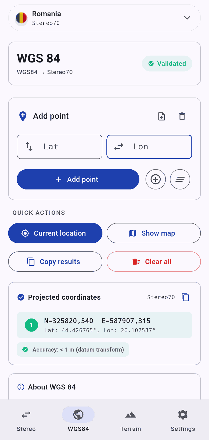
Because nothing we have measured proves centimetre. Our Bucharest reference point, WGS 84 44.426765, 26.102537, comes out of the app at Stereo 70 EPSG:3844 north 325820.540, east 587907.315. PROJ, the library behind QGIS and GDAL, puts it at 325820.542, 587907.324. That is nine millimetres apart, and the screenshot beside this text is the app showing exactly those figures.
Agreeing with PROJ is not the same as being right on the ground. A datum transformation without an NTv2 grid is metre level for Stereo 70 and S-JTSK. And ETRS89, which PUWG 1992 and the German UTM are built on, is fixed to the Eurasian plate while WGS 84 follows ITRF, so the two have drifted about 2.5 cm a year since 1989, roughly 90 cm by now, unless the transformation is given an epoch, and ours is not. Italy ships without an NTv2 grid, so it sits in the widest tier and the app says so on the conversion screen.
Check a control point you already know before you rely on any tool, this one included. We would rather you test us than trust us.
FEATURES
Complete topographic
toolkit, configured to you
Coordinate Conversion
Stereo 70, PUWG 1992, S-JTSK Křovák, Gauss-Boaga and ETRS89/UTM ↔ WGS 84, dispatched automatically per active country.
Field Measurements
Distance, bearing, area and perimeter between surveyed points, computed on the projected national grid.
Slope Analysis Pro
Slope angle, gradient and horizontal distance between two points, with elevation auto-filled from Mapbox terrain.
Import & Navigate Pro
Bulk-import points from CSV or TXT, then open any point in Google Maps or Waze for turn-by-turn navigation.
Works Offline
Coordinate conversion and measurements run locally, no internet required. Online services (satellite maps, elevation lookup) light up when you have signal.
Privacy First
GDPR Consent Mode v2, default-deny before UMP, Italian Garante ad-personalization hardening, and no account required to use the app.
How it works
Professional results in seconds
Pick your country
Choose from RO, PL, CZ, SK, IT, DE. The app routes you to your national CRS automatically.
Enter coordinates
Type, paste from clipboard or capture from GPS. The math runs on-device for instant results.
Analyze in context
Analyze slope between two points with elevation auto-filled from Mapbox terrain, and explore high-resolution satellite imagery.
Take it to the point
Copy any value to the clipboard, keep your points on the map, then open one in Google Maps or Waze and drive to it.
What is free, what is Pro
Free, with ads
- Convert between your national grid and WGS 84, both directions, no limit
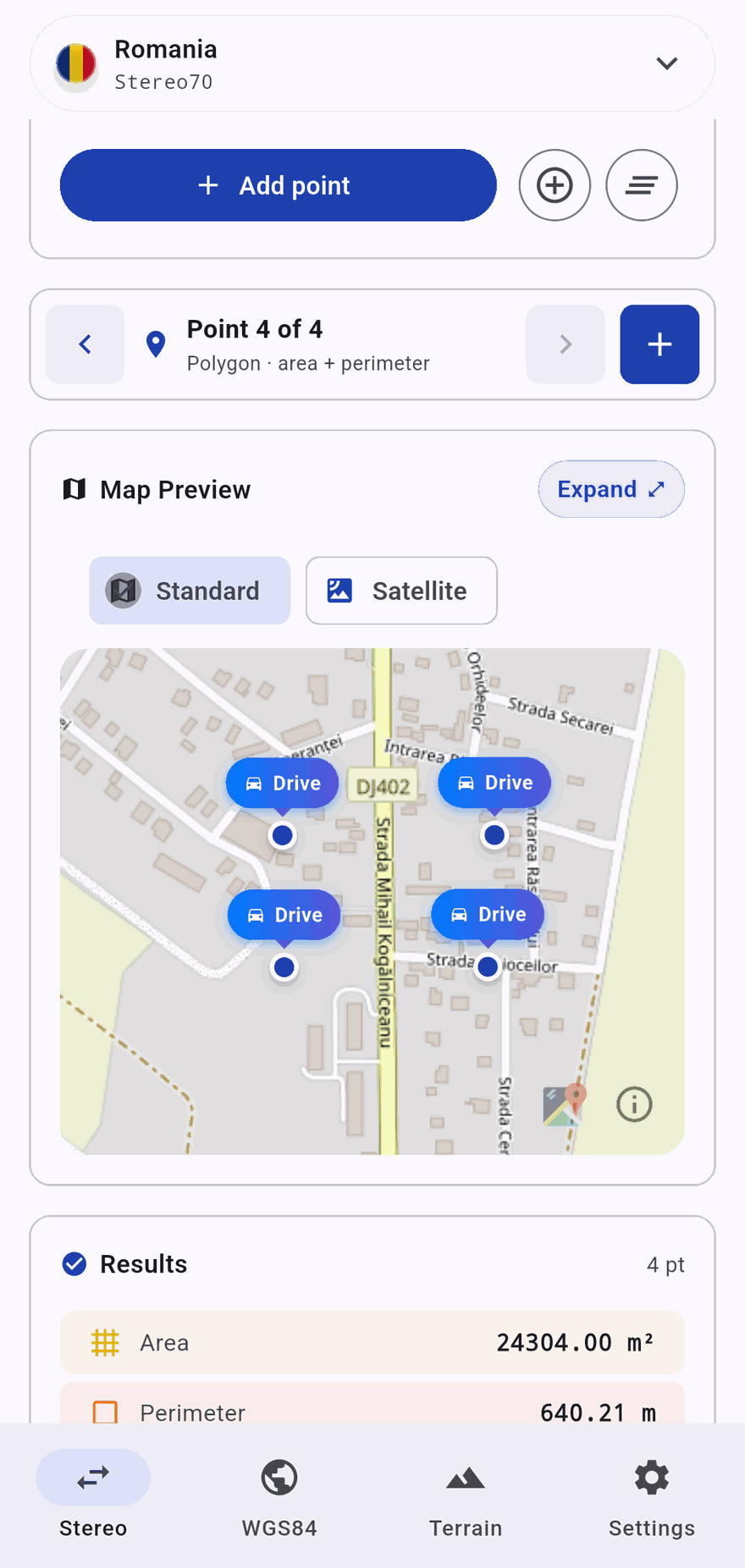
- Distance, bearing, area and perimeter between points
- Standard and satellite map
- Open any point in Google Maps or Waze
- The maths runs offline
- Seven interface languages
TopoXY Pro
- Import points in bulk from CSV or TXT
- Full screen expanded map
- Slope and gradient between two points
- No ads
Free to download. Pro is a weekly or monthly subscription with a three day free trial, billed by Apple or Google at the price shown in the app for your region. Cancel from your store settings. No account, ever.
FAQ
Frequently asked questions
Which countries are supported?
Romania (Stereo 70), Poland (PUWG 1992), Czechia (S-JTSK Křovák), Slovakia (S-JTSK Křovák), Italy (Gauss-Boaga zone 2 with UTM 32N/33N alternates) and Germany (ETRS89 / UTM 32N with UTM 33N for east of 12°E). The active country is set during onboarding and changeable from Settings.
How accurate is the conversion?
Sub-metre for Romania, Poland, Czechia, Slovakia and Germany, and roughly 1 to 3 m for Italy, which ships without an NTv2 grid. The app shows your country's tier on the conversion screen. The projection maths is checked against PROJ, the library behind QGIS and GDAL, and agrees to under a centimetre on our Romanian reference point. Agreeing with PROJ is not the same as being right on the ground, so check a control point you already know.
Does it replace a licensed surveyor?
No. TopoXY is a field tool for surveying professionals. It accelerates daily fieldwork, but official cadastral submissions still require a licensed surveyor under each country's regulations (RO Law 7/1996, DE ÖbVI, IT Collegio dei Geometri, etc.).
Does it work offline?
Coordinate conversion is fully on-device. Online services (satellite maps, elevation lookup) require connectivity. The app is honest about this: you'll see which features need signal.
What data do you collect?
Coordinates and calculations stay on your device. We collect anonymous analytics and crash reports via Firebase only after GDPR consent (UMP). No personally identifiable info. See our Privacy Policy for the full processor list.
How do I cancel my subscription?
On iPhone: Settings → [Your Apple ID] → Subscriptions → TopoXY Pro → Cancel. On Android: Google Play → Subscriptions → TopoXY Pro → Cancel. Cancellations take effect at the end of the current billing period.
Stop retyping coordinates into a desktop you left at the office.
Download TopoXY and convert like a pro across 6 EU countries.